Santana do Araguaia
Santana do Araguaia ist eine Stadt in Brazil mit etwa 32.413 Einwohnern.
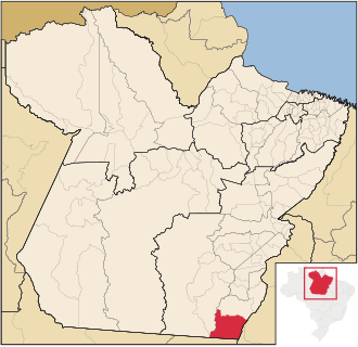
Santana do Araguaia is the southernmost city in the Brazilian state of Pará. The city lies near the Araguaia River, which marks the border with the state of Tocantins and Mato Grosso. The town was established on December 20, 1961, by then-governor of Pará, Aurélio do Carmo, after being split off from the municipality of Conceição do Araguaia.
🌦️ Live-Wetter & Ortszeit
Lade Live-Daten…
Über Santana do Araguaia
| Land | Brazil |
| Kontinent | Südamerika |
| Entdecken | 16 |
| Bevölkerung | 32.413 |
| Lokale Währung | BRL |
| Koordinaten | -9.3350, -50.3500 |
| Zeitzone | America/Belem |
🧭 Fakten & Kuriositäten
| Siedlungstyp | Kleinstadt |
| Entfernung zur Hauptstadt | 763 km · Brasília |
| Bevölkerung (Brazil) | Nr. 1153 der bevölkerungsreichsten in Brazil |
| Wo es liegt | 9°20′6″S · 50°21′0″W |
| Hemisphäre | S · W |
| Entfernung zum Äquator | 1.039 km |
| Entfernung zum Südpol | 8.980 km |
| Wussten Sie | Bevölkerungsreicher als 100% der Orte |
| Gleiche Breite wie | Calumbo (Angola) |
| Antipode (andere Seite der Erde) | 9.34, 129.65 |
✈️ Entfernung zu Großstädten
| São Paulo | 1.630 km |
| New York | 6.071 km |
| Paris | 8.257 km |
| London | 8.292 km |
| Los Angeles | 8.615 km |
| Cairo | 9.729 km |